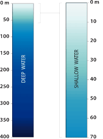
Metres below surface

Bathymetry shown only for Great Lakes
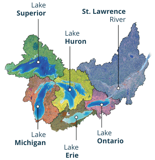
A watershed is an area that collects and directs all the water that falls within its boundaries into a larger body of water. A large watershed can be made up of many smaller subwatersheds.

| First Nations reserve (Canada) | |
| First Nation Reservation (United States)* | |
| Tribal Statistical Area (United States)** |
* First Nation Reservations include areas classes as Reservation, Community, First Nation Community and Ranch Reservation
** First Nation Land Trust Lands include State-designated Tribal Statistical Area, Tribal Statistical Area and Land Trust
![]() Treaty Boundary
Treaty Boundary
Where treaty boundaries follow shorelines including offshore islands, the boundary has been drawn to “contain” all islands in order to help visually interpret all lands and islands contained within treaty (from government data). Only treaty boundaries within the Great Lakes-St. Lawrence watershed are shown.
![]()
Indigenous language spoken today
![]()
Indigenous language not currently spoken
Historical Status
When swimming season is over, or when a beach’s water quality data has not been updated on the normal schedule (e.g., weekly), it goes into historical status. This means that rather than displaying out-of-date data, it displays the beach’s average water quality for that year.
| Green means the beach passed water quality tests 95% of the time or more | |
| Yellow means the beach passed water quality tests 60–95% of the time | |
| Red means the beach failed water quality tests 40% of the time or more |
About the data
Water quality data is provided by Swim Drink Fish through the Swim Guide program from May – September 2023. Swim Guide is the world’s most comprehensive beach information service, providing water quality data for over 10,000 beaches worldwide.
![]()
Greater flow
The flowlines on this map represent all rivers with average water flow volumes between 2 cubic metres per second (the narrowest flow lines) and about 15,000 cubic metres per second (the St. Lawrence River downstream of the Saguenay River). The flow volumes are derived from a computer-based model with inputs including climate, elevation, flow gauge and hydrologic data.
Shé:kon, aaniin, kuei, bonjour, hello! Welcome to Biinaagami’s interactive guide to the Great Lakes-St. Lawrence watershed.
Within this enormous watershed, there are more than 200 sovereign First Nations and Tribes, many of whom have cultural identities that bind them to the waters through shared responsibility. While these cultures are diverse and dynamic, they are unified in the message that it’s our role, as human beings, to listen to the waters and be their voices.
Knowing the waters is the first step. So, dive in! To the left of the map, toggle through the legends and filters to explore and situate yourself within the watershed. See how your home waters connect you to the Great Lakes and St. Lawrence River. To the top-right, zoom in and out, and try the 3D mode, where you can pan in any direction.
You’ll notice that the watersheds and subwatersheds transcend colonial political boundaries. This has meant coordinating international data between Canada and the US, and gathering accurate information from the many sovereign First Nations in the watershed. This is a work in progress. If you notice any errors, please contact us so we can review and rectify them in consultation with the respective First Nations or Tribes of the territory.